Categories
Blog

Future of the BCAG web site

I still get emails addressed to “webmaster” at this domain from various places. I got one this morning from the manager of the London Resilient Communities initiative. The domain will expire on January 15th 2027, and I am inclined not to renew it. It will be polite to unsubscribe from the various newsletters before it expires.

It looks like there is not much interest any more in a climate action group in Barnet, presumably because the climate problem has now been solved. If anyone is interested in reviving it, please contact me via the address at the bottom of the page.

Charles

Categories
Blog

Is Barnet’s Biological Bridge Falling Down?

By Dennis Ayling, August 2025

Ideally, the London Borough of Barnet should function as a beautiful biological bridge between the green belt Hertfordshire countryside and the Inner London boroughs. Is it falling down? No, not quite, but it is becoming increasingly shaky. Although it is a multi-lane bridge, the various lanes are gradually getting disrupted, potentially rendering them ineffectual. If just one span of a bridge lane is undermined, somewhere along its length, then the whole structure is compromised. Take, for example, the Edgware branch of the Northern line, long-recognised as a fortuitous north-south green lane for flora and fauna. Its open, rural-style station platforms, like the one at Burnt Oak, are of little hindrance to the passage of wildlife. 

Looking along the length of a station platform with trees the other side of the trackAn open, rural-style platform at Burnt Oak Station.

The new huge station at Colindale, bestriding the railway and coupled to the road bridge, is a different matter. This imposing building may look bright and airy at surface level but beneath, on the platforms, it is a dingy and depressing experience for train passengers. Furthermore, the new track-straddling station disrupts this green corridor, especially now that Barnet has approved two massive tower blocks contiguous with the enormous new station building. One of which is insanely planned to be over 20 stories high! Absurdly, this is said by the architects to act as a marker for the location of Colindale Underground Station: https://constructing-london.com/colindale-station-and-new-homes/. Foregoing this vanity skyscraper would have allowed a similar station entrance to be sensibly sited to the west of the railway track instead of spanning it. Green foresight would have left open, rural-style platforms at Colindale, supportive of the Edgware line's status as a wildlife corridor.

Looking along the length of another station platform with concrete the other side of the track and steel girders and roof overheadCompare the former brief bridge interruption (i.e. the two bridge arches, opposite the commuters, at the far end) to the full length interruption now.

Nobody disputes the need for increased housing provision, but the manic rush to maximise density on every square metre, as in the case of Colindale Station with its planned adjoining oppressive towers, is calamitously short-sighted. Both the wildlife and human populations will lose out in the long term, especially with climate change bearing down on us.

To be fair, the current Barnet Council is making a more than a decent effort at tackling the twin crises of biodiversity loss and climate change. It has created major wildlife habitat improvements, serving as flood alleviation areas, in both Silkstream Park and Watling Park. Barnet has many inspiring small initiatives too, like encouraging multiple "buzz stops" ["…portable pots planted with pollinator-friendly herbs and flowers that people can situate in their gardens and balconies thus providing nectar rich pathways for insects."] throughout the borough. The Borough's planning process encourages the inclusion of swift nesting sites on new buildings. A tiny forest, alongside the Mutton Brook in Finchley, had 1800 trees added to it this year. Some excellent environmental and sustainable initiatives are certainly underway throughout Barnet, overseen by its full-time biodiversity officer.

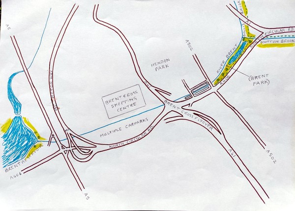
So what is the problem then? Well, biological bridge lanes, even with brilliant bits, need more. Uninterrupted continuity is critical for sustaining biodiversity, facilitating gene flow, and enabling species to adapt to environmental changes. Several super spans (e.g the Silkstream and Watling wetland habitats) are magnificent but any weak or missing spans hinders or stops the biological traffic between the outer green belt and the inner London boroughs. The south-flowing Silk Stream is beautifully enhanced near Burnt Oak's Watling Estate. In my view, the estate now rivals the more celebrated Hampstead Garden Suburb. However, downstream, beyond Rushgrove Park, this watercourse goes downhill – and not just topographically. Along this final stretch, with buildings along both banks, it is not possible to walk alongside the stream. Its environmental quality deteriorates further as it passes through an industrial zone in Hendon. Even the wooded area, just prior to it flowing into the Brent Reservoir (Welsh Harp), is a litter-strewn, neglected mess. Truly shocking, given this huge reservoir is a government-recognised Site of Special Scientific Interest (SSSI).

There is another stream of water running the length of the borough, also flowing into the Brent Reservoir, called the Dollis Brook. It has a more consistent green environmental quality along its entire length, compared to the Silk Stream. However, at the southern end of Barnet, the Dollis Brook combines with the Mutton Brook to form the River Brent. Here is where everything goes disastrously wrong, in terms of the now river serving as a wildlife corridor and green walkway. This pitiful initial section of the River Brent flows west, encased in an ecologically destitute concrete conduit. Like the Silk Stream, it too is an ugly, rubbish-strewn mess where it flows into the Brent Reservoir, SSSI. I have previously described how this environmental eyesore and ecological disaster could be totally transformed. This link proposes how Barnet's section of the River Brent could be beautifully restored: https://www.barnetclimate.org.uk/2024/06/retail-nature/ . It would become a major wildlife wetland nature reserve and flood alleviation asset at the southern, environmentally-impoverished end of the borough.

Stream with straight concrete banks and a discarded shopping trolleyThis photograph shows the barren ecological state of Barnet's stretch of the River Brent at Brent Cross.

Pond with lots of vegetation growing in the waterThis picture illustrates how the river at Brent Cross could be amazingly transformed to a natural state. It is a photograph of the wetland created by Barnet in Silkstream Park. The same could be done at Brent Cross on a much bigger scale. This would massively enrich the southern end of Barnet, which is ecologically impoverished compared to the rest of the borough. Simultaneously, it would restore the wildlife corridor from the greenbelt to the Inner London boroughs.

Surely, the aim should be to view the two water courses (Silk Stream and Dollis Brook) plus the two branches of the Northern line (Edgware and High Barnet) as four north-south wildlife corridor lanes that ought to be individually strengthened rather than fragmented. Furthermore, as the two rail tracks run close to one of each of these two water courses, they should be viewed as two sets of ecological complementary pairs. The Silk Steam and the Edgware branch of the Northern line should always be looked at in unison, as should the Dollis Brook and the High Barnet branch of the Northern line. One important feature of this overarching environmental approach must be the retention of open, rural-style platforms on both branches of the Northern line. There has been talk of "upgrading" other Northern line stations, although certainly not for wildlife!

Looking along the length of another station platform with trees the other side of the track, on the right this time.  A tube train is approaching in the distance.Open, rural-style stations do not obstruct the Northern Line rail track wildlife corridor.

Another essential aspect of maintaining Barnet's biological bridge is the ecological enhancement of parks, playing fields and even streets alongside the two branch lines and the two watercourses. For example, Hendon Park adjacent to the Edgware branch line could contribute to the rail track wildlife corridor as well as the restoration of the River Brent at Brent Cross. The aim should be to ecologically enrich and diversify the habitats within all these scattered green spaces and to link them together, including with street tree corridors.

We must recognise that two adjacent wildlife corridors, one a water course and the other a rail track, are more potent together than just one or the other. Barnet's north-south biological bridge has at least four lanes – two watercourses and two rail tracks. It also has other scattered green spaces that should be linked to these by street tree corridors and more. For example, pavement level planting, street bioswales, layered hedges along boundaries, climbing plants to create green walls, and green roofs on buildings. All these ecologically upgrade and diversify an urban environment as well as make it more climate resilient.

To summarise, in serving as a biological bridge, Barnet faces a variety of threats along its length. Undoubtedly, it has some stunning spans, but other parts are seriously damaged. Most notably, Barnet's section of the River Brent was decimated decades ago. How tragic that, just at the point of delivering biodiversity to the Inner London boroughs, Barnet's biological bridge is close to collapse. Here, one of its principal lanes exiting the borough is reduced to a poor, derelict ditch, thereby unfairly denying the residents in the southern section of Barnet the green environment and rich wildlife enjoyed by those at the affluent north end of the borough.

In assessing the ecological soundness of Barnet's biological bridge, it's not a matter of one or even two weak spots. Rather, the issue is the gradual accumulation of them, especially where housing development is now taking place. Then there are long-term existing weaknesses towards the southern end of the Borough, just at the very point where Barnet should be bestowing biodiversity upon the Inner London Boroughs. Here is where the biological bridge is currently at its most precarious. Brent Cross need not be an area of ecological dereliction, as it is now. It should, and could, be the Brent Cross(ing) point for wildlife. To the Inner London boroughs, it would be lauded as "Biodiversity Cross".

Barnet's north-south biological bridge divides at the borough's southern tip. The bridge's watercourse lanes turn west towards the London Borough of Brent. These lanes, the Silk Stream and the River Brent, flow into the Brent Reservoir and the Borough of Brent. Perhaps it is worth noting here that Brent has "higher levels of poverty and deprivation compared to the London and England averages". There is an established greenwalk and wildlife corridor from Totteridge heading south along the Dollis Brook to Brent Park. Here the Dollis Brook meets the Mutton Brook to give rise to the River Brent. Within a matter of a few hundred metres of this confluence, the greenwalk abruptly ends and the river totally loses its ecological identity, becoming a brutal concrete drainage ditch at Brent Cross. It remains in this sterile state, polluted with litter and sometimes sewage, for a long stretch parallel to Brent Cross Shopping Centre's Prince Charles Avenue. How ironic, when we recall our head of state's lifetime dedication to multiple green issues, including tackling the biodiversity and climate crises now overtaking us.

I have already shown how this environmentally-unsustainable urban disaster could be rectified in my Brent River restoration proposal, referred to earlier in this piece. Enhancing parks and other existing green spaces is of course environmentally desirable and ecologically very valuable. Such projects can significantly support biodiversity and improve climate resilience. However, to tackle the concrete and asphalt covering most of Brent Cross is of a totally different order. It requires vision and demands courage to take on such a radical transformation of the urban environment. The promotional push selling "park living" at the new Brent Cross Town is just that, and that is fine. Nobody objects to some measure of relief created by a degree of green landscaping among multiple massive tower blocks. However, it is not the lush natural environment enjoyed by residents at the northern end of Barnet. Fully restoring a meandering River Brent with a surrounding wood and water meadows, in unison with greening the Shopping Centre, would truly re-ruralise the southern end of Barnet. "Biodiversity Cross" would then serve to enrich the Inner London boroughs with flora and fauna via Barnet's beautifully restored biological bridge.

Clearly, the west-headed wildlife lanes at the southern end of Barnet's biological bridge are in need of radical repair and restoration. However, there is one substantially intact bridge lane branching east towards the Inner London Borough of Camden. As fate would have it, this is a wealthy borough. This largely undamaged bridge lane runs the length of Barnet, consisting of the Dollis Brook and, for part of its length, the adjacent Barnet branch of the Northern line.  A wildlife corridor and greenwalk that extends as far as the North Circular Road. Here, ducking beneath the carriageway, this bridge lane turns east along Mutton Brook, just south of and parallel to the North Circular Road. On reaching Hampstead Garden Suburb and progressing through Little Wood and Big Wood, Barnet's final span of this biological bridge lane is the Hampstead Heath Extension. Encouragingly, Barnet's biodiversity officer oversaw the expansion of a new wood alongside the Mutton Brook earlier this year. In my view, more needs to be done in Hampstead Garden Suburb to intensify tree corridors along its roads leading to the Hampstead Heath Extension. I made much the same suggestion to Camden Council, in relation to its residential Belsize Park area, which sits between Hampstead Heath and Primrose Hill in their borough: https://www.barnetclimate.org.uk/2025/05/primrose-hampstead/

This Camden-headed, continuous and largely ecologically consistent bridge lane is to Barnet's credit. It runs from London's green belt, across the north-south length of Barnet, then heads east and finally south to Hampstead Heath. This vital element of Barnet's biological bridge is the initial section of a green walkway and wildlife corridor, now mostly in place, that stretches from Totteridge to the Thames. Serious attention now needs to be focused on the bridge lanes heading west towards Brent, both to facilitate the passage of wildlife to Inner London boroughs and to re-green this area of Barnet, making it more resilient to climate-related heatwaves and flooding already happening with increasing frequency and intensity.

Like many others, I do weekly voluntary work on London's rivers, canals, green walkways, and the like. The tasks vary, from planting trees and hedges to monitoring water pollutants. Sometimes, I am dragging large items out of our watercourses, including shopping trolleys and electric bikes. At other times, I am simply litter-picking, though concentrating specifically on plastics. My motivation is not to 'Keep Britain Tidy', noble as that may be. Rather, I am trying to limit ocean pollution. Yes, not everyone realises what an extraordinary amount of Barnet's dropped plastic bottles and bags gets carried downstream. Barnet's watercourses propel the increasingly fragmented plastic down to the River Thames where it is eventually carried out to sea. It comes as a big shock to many residents that the London Borough of Barnet is adding microplastic to our oceans.

Environmentally, there is much to do on many fronts. Resident volunteers can do a lot to help, but there are major environmental tasks only our local and national government can address. Clearly, Barnet Council is an eco-friendly governing body. It is particularly fortunate in having some outstanding ecological assets at the north end of its borough. I raised my young family at Monken Hadley with Hadley Green, King George's Fields, Hadley Common and Hadley Woods just a stroll from our tiny one-bedroom cottage. As a young teacher, I had previously lived near Brent Cross, confined between the constantly busy North Circular and Great North Way roads. Here, at Brent Cross, is where Barnet Council's values, vision and courage is called on. Virtually daily, we are being given new insights into the multiple and profoundly serious climate-related environmental issues already threatening us. The time to tinker, however well-meaning – like my personal efforts to hold back the tide of ocean-bound plastics – are numbered. Radical, super-scale initiatives must be urgently implemented by a Barnet Council that is, hopefully, not only environmentally informed but is also truly insightful about our planet's perilous future. Instead of the current gradual undermining of Barnet's biological bridge, it should hurriedly be built back better, especially at its southern end. Yes, housing development is a priority, but so is surviving climate change and adapting to the extreme temperatures and frequent, catastrophic flooding it brings. Urgently attending to the repair and maintenance of Barnet's biological bridge lanes will not only be a massive ecological benefit to the whole of Barnet, but it will also assist the Inner London boroughs in addressing the now enveloping climate and biodiversity crises too. 

Map of the southern part of the borough of Barnet with green lines drawn along the wildlife corridorsBarnet's biological bridge lanes – rail tracks and water courses (the latter feeding the Brent Reservoir, SSSI)

Finally, let us consider the much wider imperatives of fixing Barnet's biological bridge, especially where it was biologically butchered by botched town planning half a century ago. Clearly, the complex of road intersections at Brent Cross have become a transport necessity. However, it does not follow that they have to impose ecological dereliction on the surrounding area. Think for a moment of our national motorway verges. These strips of land, adjacent to busy six-lane carriageways of fast-moving traffic, have become wildlife corridors: https://theecologist.org/2024/aug/15/road-verges-can-save-britains-biodiversity. The traffic passing through Brent Cross and over its flyovers could be screened visually, and for noise, by a dense band of trees. Remember, too, that we are gradually advancing towards quieter, non-polluting electric cars and buses. I put my long-standing proposal for the twin objectives of river conduit enhancement and vital climate resilience measures at Brent Cross online in 2022. In that proposal, I advocated using three Barnet borough owned car parks to create a wood and wetland for flood alleviation purposes and heat wave mitigation. Given that the climate and biodiversity crises have alarmingly intensified and swiftly accelerated since then, I felt compelled to go further. We must urgently and vigorously push ahead to meet these twin global crises. A complete restoration of the River Brent, instead of just an improvement of its existing concrete channel, is now required. It would set an inspiring new precedent for urban adjustment to future city life, taking into account the dangerous health risks posed by climate change.

Although ecologically enhancing our fragmented urban green areas is valuable, it is far from sufficient since the climate in the UK has already altered in severity: https://www.bbc.com/news/articles/c74w1gyd7mko. Unfortunately, such green space efforts amount to tinkering at a political level, given the still unacknowledged enormity of what is bearing down on our world. We have to wisely and creatively adapt the built urban environment to face the detrimental consequences of global warming. To achieve climate resilience and liveability the latest research advises that urban greening needs to be nature based and to utilize green-blue-grey infrastructure: https://www.frontiersin.org/journals/sustainable-cities/articles/10.3389/frsc.2025.1595280/full. I recognise that some of the concrete and tarmac at Brent Cross has to remain for transport purposes, yet it could, with scientific-based vision, be radically and uniquely transformed. At a stroke, such a novel paradigm would re-ruralise the blighted southern end of Barnet. If it were enacted, it would undoubtedly capture national and  perhaps international attention as a revolutionary new paradigm for urban adaptation to both climate change and biodiversity loss. What a momentous contribution from UK leadership that would be in addressing the existential danger posed by these twin crises.

I have said many times that I believe Barnet, under its new council, could be a national and quite possibly a world leader in showing the way to develop urban climate resilience and biodiversity restoration at one of London's most daunting and challenging city locations. If Barnet were to apply a nature based solution (NbS) utilizing green-blue-grey infrastructure (GBGI) as I have suggested, this multiplex of road intersections, which includes three flyovers, could be transposed from a hideous urban nightmare to a beautiful environmental dream. I urge Barnet to heed the latest research, to be daring, original and visionary for the future of all life on planet Earth.

Dennis Ayling

Dedicated to Julian, on whom I rehearsed my outdoor parenting skills

Categories
Blog

Totteridge to the Thames via Camden’s Dormant Country Corridor

Dennis Ayling explains his proposal for a tree corridor between Hampstead Heath and Primrose Hill.

For another article by Dennis Ayling, see A New Retail and Nature Partnership to Beat Climate Change.

The greenwalk from Totteridge to Hampstead Heath is well established. It follows the Dollis Brook and then the Mutton Brook to Hampstead Garden Suburb. It continues through the Garden Suburb via Little Wood and Big Wood to Hampstead Heath Extension. Once across the Spaniards Road, it's possible to follow the two spring-fed headwaters of the River Fleet. Both of these streams have been dammed to form a series of ponds. The Highgate Ponds to the east can be followed to Gospel Oak. The Hampstead Ponds to the west lead to South End Green. From Hampstead Heath, the River Fleet flows south underground to feed the River Thames. Therefore, it would appear our greenwalk terminates at the charming southern fringes of Hampstead Heath.

a view of a road between two big tree trunks, with red brick houses and a block of flats in the distance.  The sun is shining and there are several bicycles parked.The southern exit from Hampstead Heath onto South End Road

Well, not quite. There is a dormant country corridor that, if substantially enhanced, could extend our greenwalk further. Instead of the ideal river wildlife corridor, which we are currently denied by the burial of the Fleet, there is potential for an urban tree corridor to take us on towards the River Thames. Let us, for a moment, hop to Limehouse Basin where the Regent's Canal joins the Thames. The Regent's Canal is an established greenwalk and wildlife corridor currently being bettered by Thames21. If we now hike back from Limehouse, along the towpath through the East End and towards King's Cross, we will come to Camden Lock. A little further still, will bring us to Regent's Park and the London Zoo on the south bank of the canal and Primrose Hill Park on its north side. A glance at a map will show that there is a relatively small urban area between the northern edge of Primrose Hill and Hampstead Heath's southern fringe. If this built up interruption was bridged with a tree corridor(s) [https://arboristnow.com/news/urban-trees-nature-s-highways-for-wildlife-in-2024/] we would have our complete greenwalk from Totteridge to the Thames.

As it happens, Hampstead has long been referred to as leafy Hampstead. Trees in the high street reach across the width of the road to merge and form a green canopy.  The same green moniker could be applied to Belsize Park, slightly down the hill from Hampstead High Street. It, too, has always been a leafy district. I lived in a modest Hampstead flat during the 1940s and 1950s. As a child, running free on the Heath, I developed a love of Nature. Later, I attended Haverstock Comprehensive School at Chalk Farm and became acquainted with Primrose Hill and the London Zoo as well as the Regent's Canal between them. Sometime in my youth I came to see them as a continuum. It registered with me that my morning saunter to school, down Haverstock Hill, was the paved link between the green of Hampstead Heath and that of Primrose Hill and Regents Park. I think it is long overdue, given the climate and biodiversity crisis, that this early vision is turned into an environmental reality. Of course, there are a number of well established walks in the Belsisze Park area. There is even a designated street route between Primrose Hill and Parliament Hill. I am envisioning something altogether different and much more ambitious – a multi-lane wildlife corridor to urgently address both climate change and biodiversity loss.

The UK is one of the most nature-depleted counties in the world. Alarmingly, biodiversity loss is still continuing at the present time. Confronted with this dramatic and devastating loss of vital wildlife during my lifetime, the most resilient green link possible needs to be established between the Heath and Primrose Hill. It is essential to develop multiple uninterrupted dense tree corridors through the urban zone between these two green habitats. Doing so will simultaneously address the parallel crisis of climate change. We are now facing more frequent heat waves of greater intensity and duration. A really significant tree canopy will not only reflect solar radiation but provide shade as well as the cooling effect of evapotranspiration for city dwellers. It will also greatly reduce the absorption and then re-emission of solar energy by road and building surfaces. More frequent and more severe flooding is another deadly consequence of climate change. Trees in large numbers help reduce urban flooding by absorbing water through their roots. Tree roots also create channels in the soil. These macropores, which allow rainwater to infiltrate the soil more effectively, reduce surface runoff and therefore the risk of flooding.

The Camden country corridor I imagined in my youth, long before the current desperately diminished state of our wildlife, must become an immediate priority. It requires not only looking at any gaps in tree planting but also a variety of underplanting including in kerbside Suds. The protection of many magnificent garden trees, shrubs and other wildlife-supporting plants needs to be included. Residents have to be informed about the high worth of their properties to a wildlife corridor and incentivised to participate in creating and maintaining it for both wildlife and citizens alike.  Every means to ruralise this urban interruption must be explored. Are there places where layered hedging would work? Are there buildings and surfaces that would support climbing plants to bolster pollinators and provide bird nesting sites? Both hedges and climbing plants shelter invertebrates. These creatures serve a crucial role at the base of the ecological food web. Are there buildings where wet green roofs could be employed? They help to diversify the local habitat and absorb rainwater, reduce runoff, and thereby alleviate urban flooding by slowing down water flow and allowing it to evaporate. Bioswales and rain gardens are another way of ruralising the urban landscape. They are supportive of biodiversity and would mitigate flash flooding due to climate change induced deluges. Belsize Park would be a park and no longer just in name.

The most direct and leafy route by road from the southern fringe of Hampstead Heath to the northern edge of Primrose Hill begins by stepping off the Heath into South End Road. The bottom end of which is deprived of trees in part due to the railway tunnel serving the local station. However, South End Road is very green around the memorial fountain just before you turn onto Pond Street.

a road with big trees and the memorial drinking fountain with pointed arches in a parkSouth End Road

As you ascend Pond Street, the massive Royal Free Hospital looms over the road, but it does have large trees and a strip of garden running along its front. Two thirds of the way up the hill is a pedestrian passage on the hospital side that passes by Hampstead Green – a small triangular meadow with scattered trees. It is managed for wildlife and uses a mowing scheme that allows the wild plants to flower in support of pollinators.

view of a park with a noticeboard and railings with rounded topsHampstead Green

This passage leads on to Haverstock Hill, which descends towards Chalk Farm. There are many magnificent trees both on the roadside and in gardens flanking this road. Some recent tree planting has been done, too, however gaps remain, and much more could be achieved to ruralise this main road. As you descend this hill, it has a well established leafy square just before the local tube station. Perhaps this could be enhanced with planting at pavement level. A water garden served by a bioswale is a possibility. Radical rural enhancement could turn Haverstock Hill into Camden's country corridor.

a road with a wide pavement, trees, a bus stop and benchesHaverstock Hill

As we continue downhill and pass Antrim Grove the branches of one massive plane tree reach across the width of the road. Why not have an overarching leaf canopy here – as in Hampstead High Street – towards the top of this same hill? Carrying on down to England's Lane, there are more arboreal gaps to fill. As we pass the Sir Richard Steele Pub, the absence of trees is more marked, as it is further down the hill.

a pub with hanging baskets on a wide road with cycle lanesSir Richard Steele Pub, Haverstock Hill

Why not aim to create an overarching tree canopy the length of Haverstock Hill, especially as it now has cycle lanes? The twin crises of biodiversity loss and climate change call for radical ruralisation of our towns. Turning right into Steele's Road we continue along our relatively leafy route. Pollarded planes line both sides of this peaceful road.

a road lined with large treesSteele's Road

As we branch into Fellows Road, there is an arboreal gap before trees overarch the road to form a short, leafy tunnel. The final stretch has several more gaps but ends with two giant planes on the corners.

a leafy urban road with blocks of flats behind treesFellows Road

Here we turn left on to the busier Primrose Hill Road. It is quite leafy on the right hand side, largely due to garden trees. A reminder of the vital role local residents can play in creating and sustaining urban green corridors. However, there is plenty more room for tree planting to create a true arboreal wildlife corridor.

another road with trees and blocks of flats, and weird curved tubes which maybe are for locking your cycle toPrimrose Hill Road

Shortly, Primrose Hill Road crosses Adelaide Road and again with arboreal gaps brings us to the northern end of Primrose Hill Park. It should be noted Adelaide Nature Reserve, on the railway embankment, is close by and should be incorporated into this primary branch of Camden's country corridor.

a big tree in a park with fallen leaves below itPrimrose Hill Park, Primrose Hill Road

Potentially, there is a second green corridor traversing this urban barrier that separates Hampstead Heath and Primrose Hill. It begins by stepping off the Heath at the top end of South End Road and walking up Downshire Hill. There are no roadside trees on this relatively narrow road. However, there are quite a few in the front gardens of the houses on the north side of the road. I believe the back gardens of these houses, in themselves, are supportive of wildlife. The parallel Keats Grove is a similar narrow road with very leafy gardens. Where Keats Grove links with Downshire Hill, the latter widens. The top, wider length of Downshire Hill has a solitary plane tree. I believe this end of the hill could accommodate more street trees. Turning left on to Rosslyn Hill, again there are many garden trees as well as some roadside trees. Relatively recent tree planting has filled some gaps, but I would suggest there is a need for more roadside trees, especially towards Hampstead Green. The same applies to the stretch between Hampstead Green and Belsize Avenue. A right turn on to Belsize Avenue brings us into another foliage-covered way until we approach Belsize Park Gardens where it thins out somewhat. Turning left and continuing along our second selected green corridor, the trees of Belsize Gardens become even more sparse. Along this road the trees, including a few magnificent specimens, are mostly in the gardens. There are only five or six mature plane trees on the roadside and one or two recently planted rowan trees. Surely, many more of similar smaller species could be added to the length of this road. On reaching the junction with England's Lane, Belsize Gardens ends and Primrose Hill Road begins. In this wider road I counted only one kerbside tree before Primrose Hill Road crosses Adelaide Road. It is true, there are some large garden trees on this stretch but it needs some street trees to give continuity of foliage along its length. After crossing Adelaide Road, almost the same can be said of the final stretch of Primrose Hill Road right up to the entrance of Primrose Hill Park.

a map with the route from Hampstead Heath to Primrose Hill

Helpfully, all these routes can be explored virtually on Google Earth.

A quick way to visualise the layout of these potential multiple tree corridors between Hampstead Heath and Primrose Hill is to place your right hand, palm down, with your thumb open to the side. The thumb now stands for South End Road and Pond Street leading to the index finger, which depicts the length of Haverstock Hill pointing towards Primrose Hill. The thumb could also be a representation of Downshire Hill and Rosslyn Hill, leading to the knuckle of the index finger. The four knuckles serve to trace Belsize Avenue, while the middle finger stands for the sequence of Belsize Park Gardens and Primrose Hill Road leading to Primrose Hill. The ring finger and small finger signify other parallel turnings off Belsize Avenue pointing in the direction of Primrose Hill too. In the face of rapidly accelerating climate change and biodiversity loss, this simple model illustrates how an environmentally-enhanced Belsize Park area could serve a vital helping hand to both Nature and Humanity.

Dennis Ayling

Dedicated to my kind Kiwi friend, Ronnie

Categories
Blog

A New Retail and Nature Partnership to Beat Climate Change

By Dennis Ayling, June 2024

In presenting this proposal I am inevitably going to dish up some doom and gloom, but fear not. Ultimately, I am an optimist about the future of our planet. I am going to detail an unpleasant blot on our landscape and then suggest how it might be unbelievably transformed. It will achieve much more than the greening of a dreary place. It will serve to protect our physical and mental health along with the well-being of Nature, on whom we utterly depend for our basic needs. In fact, it will go even further. It is no exaggeration to say this unusual alliance of Retail and Nature will contribute to ensuring our survival in the face of frequent extreme weather events.

No, I do not have a vast sterile gravel pit or a mountainous row of slag heaps in mind for transformation. I am thinking of a gigantic road interchange – a highway hell. It sprawls across an area at the southern end of the London Borough of Barnet. Here, there is a messy complex of massive roadway systems that occur along a stretch of the North Circular Road (A406) from its junction with the Great Northway (A1) to where the Edgware Road (A5) flyover straddles the A406. The major carriageways in this zone are A1, A41, M1, A5 and A406 (see Sketch 1). This multiplex of intersections includes three flyovers. Beneath these massive concrete bridges is a labyrinth of dirty roads, desolate and dingy footpaths, along with bald islands of bare soil and scruffy banks of grass. In the middle of this urban planning disaster sits Brent Cross Shopping Centre. This then is the Retail component alluded to in the title of this piece. What of the Nature element also mentioned at the head of this proposal? Well, running through the interchange labyrinth is a concrete conduit that, shamefully, is the initial section of the River Brent. At first sight, any visitor to this urban nightmare could be forgiven for dismissing this conduit as an ugly drainage ditch.

straight stream between concrete walls with rubbish on the stream bed but some nice small trees on the banks above the walls

In reality, it is the river link between the very green river catchment area of northern Barnet and a southern Site of Special Scientific Interest (SSSI), the Welsh Harp Reservoir. Here then is the UK's oldest indoor shopping centre with an important but shockingly neglected river flowing past its front door. Almost the entire vicinity of the Shopping Centre, with its adjacent vast complex of major road systems, is made up of impermeable surfaces. All this urban construction has occurred on former marshland in the valley of the River Brent, inevitably making it a flood risk zone: https://www.mylondon.news/news/north-london-news/london-stretch-m1-motorway-becomes-27110356

hand drawn map showing the straight part of the stream between Brent Park and the Welsh HarpSketch 1

Let us, just for a moment, fully face the doom and gloom of this predicament, so that we are informed to optimistically refashion this urban disaster in an age of climate change and biodiversity loss. Putting aside the dreadful appearance of this ugly and polluted part of North London, there are three main existential issues. First, in a river valley, acres of impervious concrete and asphalt will result in devastating flooding in the face of frequent climate-related intense storms. Second, the same materials will cause life-threatening temperatures during climate driven heat waves (1). Unlike the original river valley vegetation, all this concrete and asphalt creates a severe heat island effect (2). The third matter is the loss of the river wildlife corridor, given that this part of the River Brent now runs in a concrete conduit. Clearly, this is a hostile habitat for flora and fauna. Of course, there is much more detail to the story than these three major consequences, in the face of the now rapidly escalating climate and biodiversity crisis. Earlier, I promised to switch from doom and gloom to optimism and a solution, so let us do so. Now we have established that deluges, heat waves and wildlife extinctions have become critical, and that all three are life-threatening to us, we need a radical and rapid way out.

I have, in the past, already put forward significant suggestions for addressing the environmental and climate related issues in this part of North London: https://www.barnetclimate.org.uk/2022/06/biodiversity-dollis-brent/. However, this former piece, though making ambitious and quite radical proposals to tackle the biodiversity and climate crisis, essentially advocates an exhaustive enhancement of Barnet's section of the River Brent. My new proposal will unite Retail and Nature in a partnership to go further and restore this section of the river to a more natural state. The latest scientific research and regularly observable extreme weather events around the world, along with the decline and loss of species, now necessitate that we do much more and faster in response to climate change. The fact that we have just recorded a global temperature exceeding 1.5 C above pre-industrial levels for a full twelve months is a step change in the wrong direction (3). London has had its own urgent wake up call from the London Climate Resilience Review. It found our capital city is underprepared for the frequency and severity of climate change effects currently being experienced (4). Then what of the future when weather events will be more frequent and severe?

All over the USA, large shopping malls are failing (5). I have witnessed them decline in Texas, where I have family. In my proposal of June 2022, I identified three car parks immediately south of the River Brent in front of Brent Cross Shopping Centre. Planning permission has been given for an enormous expansion of the Shopping Centre across these car parks, which would push the River Brent into the gutter of the North Circular Road, where 12 lanes exist. Apart from this disastrous re-routing of the river, a vast retail building expansion would totally undermine the urgent severe weather resilience called for in the Mayor of London's current Climate Resilience Review. However, there is a potential way for some malls to make a dramatic comeback by reinventing themselves for contemporary and anticipated future circumstances. Rather than expanding into a white elephant, Brent Cross Shopping Centre has the exciting prospect of metamorphosing into a major environmental asset and becoming an inspiring sustainable retail leader on its present footprint. It has the unique title of being the UK's first indoor shopping centre. Think of this historic status plus its brutalist architecture as an interesting starting point. It's this exclusive position that holds the key to rethinking the notion of the Brent Cross Shopping Centre. Made of impermeable and heat retaining materials and built in a river valley, its commercial viability now sits on the foundation of being a potential environmental hazard. Forthcoming frequent severe weather events will add to it being an ecological menace. What if all these negatives could be flipped by a visionary Retail and Nature partnership – something that our Monarch might perhaps envision. After all, Brent Cross Shopping Centre was opened by Prince Charles who is now recognised as one of the world's foremost environmentalists.

The extensive car parks south of the River Brent, sited immediately in front of the Shopping Centre, are owned by the London Borough of Barnet and leased to the Shopping Centre owners (see Sketch 2). Here then is the nucleus for a visionary and exciting new partnership between Retail and Nature. The core of a radical new paradigm in which the owners of the Shopping Centre and the Council come together to initiate a truly tremendous change. Jointly with other agencies, they could boldly bring about a major environmental transformation. A metamorphosis of the magnitude now being urgently called for to avert climate-related disaster. Further to my detailed proposal of June 2022, I would have the River Brent restored, with natural margins of riparian vegetation, to meander through a meadow and woodland where the current car parks exist (compare 'before and after' Sketches 2 & 3). Having revived the heart of Brent Cross with a now healthy river artery, let us add flesh and bones to this urban environmental restoration. Be in no doubt, I am proposing action on a town planning scale. Conventional drainage pipes, no matter their diameter, under acres of concrete and asphalt will be hopelessly inadequate for coping with future deluges. Additionally, these extensive hard areas will absorb solar energy and release heat causing insufferable temperatures for Londoners. However, there are answers if we modify our urban environment to be more porous and to greatly increase vegetation in the vicinity of the Shopping Centre and its surrounding complex of roadway intersections. Not only will this transformation of the leased car parks into meadow and woodland increase porosity, the new vegetation will serve to cool the area by shading and evapotranspiration. Moreover, there are significant zones under and around the bases of both the North Circular and Brent Cross Flyovers that could be enhanced as part of the re-greening of this vast traffic interchange. Collectively, these actions will create a sponge for soaking up heavy inundations and a heat shield for easing the impact of extreme heat waves. All of which will additionally benefit the River Brent as a natural wildlife corridor.

sketch showing a tower block marked 'Holiday Inn', cars and car parks and the straight streamSketch 2

sketch showing the same tower block marked 'Holiday Inn' and cars but the stream is now curved with more treesSketch 3

The demise of large shopping malls in the US is well known. Those malls that remain have reinvented themselves. It is worth noting that place perception is important for retail sales. A University of Washington report states "shoppers claim they are willing to travel more often, further and for longer times to visit retail environments with pleasant tree cover. Also, shoppers indicate that once arriving they will spend more time in a retail district with trees." (6). For survival, "The needs and interests of the local community should be the guide to what activities are most appropriate." (7).Ergo, rather than spread yet more massive amounts of impermeable building material across Brent Cross, hold back and embrace Nature. Yes, instead of committing a life-threatening environmental crime, support Nature and thereby protect the safety of the local community and green their neighbourhood. Reimagine Brent Cross Shopping Centre as a sustainable combined retail enterprise and nature reserve coupled to the Welsh Harp Reservoir (itself a Site of Special Scientific Interest). At the same time as restoring the River Brent, redesign Brent Cross Shopping Centre in a sustainable manner on its current footprint. Assuming the River Brent to have restored natural margins with riparian vegetation for most of its Barnet stretch, re-greening could then be extended to the historic Shopping Centre. This would include extensive tree planting around the Centre's parking areas in company with permeable car park paving. Prince Charles Way, fronting the Centre, would be enhanced with an avenue of trees and serve only electric buses, cyclists and pedestrians (see Sketch 4). Cars would enter and leave the rear car parks at the east and west entry points. The section of Ethertheridge Road between the east and middle leased car parks would be removed. It is only there to serve a bus stop on the North Circular Road that could easily be repositioned a little to the west, adjacent to another pedestrian bridge.  I have many detailed suggestions aimed at distancing traffic from the restored river and bringing the Centre and River Brent together as a single green entity. Included are pedestrian/cycle paths and a picnic spot alongside the restored river. The paths would connect the Welsh Harp via a Shopping Centre riverside walk to the Dollis Valley Greenwalk.

sketch of Brent Cross shopping centre with a green roof, swift nest boxes, trees and an electric bus.  A note says 'Permeable parking surfaces all around'Sketch 4

The Centre's retail aspect could evolve towards offering more sustainable products and fashion. It might also endeavour to attract novel and climate-aware restaurants. The UK's first US style 'shopping mall' has an opportunity to record another first and lead UK retail in positively facing the age of climate and biodiversity challenge. The brutalist architecture of the Centre's building could be adjusted to make it progressively more sustainable too. A green roof comes to mind. In addition to reducing flooding, these roofs absorb solar energy. This has a cooling effect and decreases the need for air conditioning. Additionally, they absorb the greenhouse gas carbon dioxide, and provide a whole extra ecosystem for wildlife. Swift nesting sites could be added to the facade (Barnet requires the provision of these on new buildings). This feature could be especially valuable alongside a restored river, given swifts feed over rivers and their margins. Vertical vegetation on the building may also be an option to provide another valuable habitat as well as contribute to cooling. Bear in mind, there is an architectural style called eco-brutalism. Internally, biophilic design might be employed to continue a sense of wellbeing engendered by the green exterior. Clearly, there are many details and much specialist advice to be mulled over. However, it is not hard to see how a new green, climate-resilient Shopping Centre could be coupled with a restored River Brent and the nearby Welsh Harp Reservoir (SSSI) to form an exciting new union of Retail and Nature – the Brent Cross Shopping and Wildlife Centre. The owner's building might boast a massive sculpture of a Brent Goose displaying their commitment to supporting our planet's biodiversity (see Sketch 4).

The Shopping Centre already has an Underground rail link plus a new Thameslink station nearby and it will soon be served with zero emission buses. Therefore, the Centre has good sustainable links. It now needs to become an attractive, interesting and sustainable destination for all, especially the younger, climate concerned generations. Shopping malls "need to be more experience based, rather than just a place to buy things" (7). They must also "become more community focused by hosting regular events, or offering services that cater to the needs of the local area" (7). A partnership of Retail and Nature could achieve this model.

In my proposal of June 2022, I demonstrated how involving the local community in environmental projects has already proven to work elsewhere. I argued for a borough-wide scheme that would largely green the entirety of Barnet through engaging residents in garden practices that support wildlife, following the community nature reserve principle (8). There are already wonderful volunteer groups doing environmental conservation work in many parts of the Borough, including its river catchment areas. A new Shopping and Wildlife Centre would be the obvious place to have a Barnet wildlife indoor amenity for all the Borough's environmental endeavours. A meeting place for everyone interested in Barnet's biodiversity and climate concerns. It could include an exhibition space to showcase the Borough's and individuals' environmental work. It would have close links with Brent's excellent, well-established Welsh Harp Environmental Education Centre (9).

Above, I have outlined a monumentally ambitious proposal, on a town planning scale, that will require public and private finance to be achieved. However, there is a new urgency.  All our scientific monitoring, plus the observable catastrophes and widespread loss of life in the global south, suggest global warming is accelerating. It is now widely acknowledged that the world should have acted more decisively and much earlier in cutting carbon emissions. Climate change and biodiversity loss have now overtaken us. We are currently faced with both cutting our carbon footprint over the long term and urgently adapting to the now inevitable extreme effects of the climate and biodiversity emergency. I strongly believe a project, both transformational and profoundly beneficial, is urgently called for in the face of this rapidly escalating planetary crisis. Something that will not only make a dramatic difference but will act as a catalyst to initiate a rethinking of our capital city. I have chosen the hideous Brent Cross multiplex of road intersections, a nightmare of poor urban planning. A place where the towel was thrown in over half a century ago. Taking this on as a project will offer a striking and inspiring paradigm for other unpromising places in Greater London as well as other cities both nationally and internationally.

My radical restoration proposal for the Brent Cross area offers Barnet Council and the Shopping Centre owners the opportunity to become national leaders in this age of climate change and biodiversity loss. There is no question that it is a challenge requiring heroic visionary foresight, but the gains would be enormous for the future welfare of us all. Apart from transforming this part of North London, it would lead the way nationally by inspiring others to do likewise, on a similar monumental scale. What of the Shopping Centre's owners and their investment in this proposal? Does foregoing physical expansion lead to a loss of profit and the demise of this particular retail centre. I think not.  At a time of online shopping and other major changes following the recent pandemic, shopping centres must become attractive green destinations for more than simply retail. This model of a combination of Retail and Nature has already been developed successfully in an out of town village location: Peak Village Shopping Centre and Derbyshire Wildlife Trust (10). I am not aware of such a partnership between Retail and Nature in London or in any of our major cities. The owners of Brent Cross Shopping Centre would not only be investing in their historic first UK site as a destination for shopping, eating and laid-back relaxation at a nature reserve site, they would be the world leaders in providing sustainable, climate-resilient urban living. They would be investing in an admirable contribution to King Charles' sustainable markets initiative, which places sustainability on a par with profitability. "The 'Terra Carta' offers the basis of a recovery plan that puts Nature, People and Planet at the heart of global value creation – one that will harness the precious, irreplaceable power of Nature combined with the transformative innovation and resources of the private sector." – The former Prince of Wales (11).

Dennis Ayling

Dedicated to my son, Sean, and my daughter, Emily

References:

(1) 10,000 people a year could die as a result of heatwaves, MPs warn

https://news.sky.com/story/10-000-people-a-year-could-die-as-a-result-of-heatwaves-mps-warn-13060463

(2) Urban Heat Island

https://skepticalscience.com/graphics.php?g=251

(3) ‘Grim’ global warming figures are ‘clarion call’ for resilience to move up agenda, engineers warn

https://www.newcivilengineer.com/latest/grim-global-warming-figures-are-clarion-call-for-resilience-to-move-up-agenda-engineers-warn-08-02-2024/

(4) Climate change: London is underprepared for extreme weather

https://www.bbc.co.uk/news/uk-england-london-67993950

(5) Mall Closure Statistics

https://capitaloneshopping.com/research/mall-closure-statistics/

(6) The benefits of urban trees

https://www.warwickdc.gov.uk/info/20323/trees_and_woodland/577/the_benefits_of_urban_trees

(7) Why Are Shopping Malls Dying, and How Can They Make a Comeback?

https://www.eposnow.com/uk/resources/why-are-shopping-malls-dying/

(8) Urban community nature reserve

https://www.avonwildlifetrust.org.uk/team-wilder-community-nature-reserve

(9) Welsh Harp Environmental Education Centre

https://www.thames21.org.uk/welsh-harp/

(10) Peak Village, Rowsley

https://peakvillage.co.uk/

(11) Terra Carta

https://www.sustainable-markets.org/terra-carta/

Categories
Blog

Biodiversity and climate change in North London

By Dennis Ayling, June 2022

This is about a missed opportunity in North London that has repercussions for Inner London boroughs, too.

Everyone now knows we are facing two interlinked emergencies: a devastating decline in biodiversity and catastrophic climate change.

Both threaten our survival, yet both were predicted over 40 years ago. Both are now crises over which we are imminently losing control.

In 1962, Rachel Carson's Silent Spring was published (1).

In 1979, a US National Academy of Sciences report (the "Charney report") found it highly credible that doubling CO2 will bring about 1.5–4.5 °C of global warming (2).  

This spring, the IPCC released the third part of its Sixth Assessment Report (3), looking at ways to limit & prevent human-caused emissions that contribute to global warming. “It’s now or never, if we want to limit warming to 1.5 °C." – IPCC Working Group III Co-Chair Jim Skea 

Why then, one wonders, is the London Borough of Barnet making its biggest mistake of the century in the face of the climate and ecological crisis?
Barnet is failing, at a pivotal moment in history, while all around the world others are producing imaginative and successful solutions to meet current global environmental challenges. The crying shame is that Barnet, with a little more courage, could be an enlightened civic leader for London, the UK and even internationally.

This is not a time to mince words. Let me set the context for my emphatic assertion, and then you should judge whether or not Barnet is passing up the chance to be a world leader in the face of the ecological and climate crisis.

I grew up in Barnet and I spent most of my adult life teaching in schools in the Borough. I have lived and taught in the southern end of Barnet, and I raised my own children and taught in the very green, northern tip of Barnet. I have had a lifelong love for this beautiful part of London. It is this passion for Barnet that compels me to readdress an issue I first raised over 40 years ago. At that time, I was living in Southbourne Crescent. My lodgings there were sandwiched between the rumbling Great North Road and the roaring North Circular Road. However, the rear gardens at Southbourne Crescent backed onto the Dollis Brook, close to where it gives rise to the Mutton Brook and the River Brent.

Let me start with the Dollis Brook, which already shows what is possible, and then go much wider. At Southbourne Crescent, I quickly found that I could walk north from our back garden alongside the Dollis Brook right out to the Totteridge Valley. It was an enjoyable discovery especially as it supported some significant wildlife. As a biologist and a member of the Herts and Middlesex Trust for Nature Conservation I was excited by the potential of this natural corridor. I saw kingfishers at the southernmost end of the Brook and identified aquatic indicator species in the stream that testified to its health. I began to consider how the Dollis Brook might be managed to enhance its wildlife. At the time, most of its length was a mown grass monoculture. Additionally, selective weed killer was being sprayed to maintain the brookside lawn-like appearance. I wrote to the parks superintendent suggesting that at least some areas should be managed like a hayfield to allow a proliferation of wild plants. This in turn would support a greater insect population, bird species, etc. I also advised ending the weed killer spraying because of runoff into the stream and consequent damage to the aquatic ecology. My suggestion to manage the Dollis Brook as an urban wildlife corridor was not taken seriously by the parks department. I tried writing to the local press. I recall at least one of my letters was published but nothing came of that either. However, after many decades, the Dollis Brook is now managed to support wildlife and provides a vital outdoor urban green footpath. So far so good, but what of the massive error on Banet's part?

Indulge me a little longer and I will show how the Dollis Brook, though important, was one element of a wider more profound ecological proposal. After my discovery of the Dollis Brook I started to look at the ecology of the borough more holistically. The north end of the Borough of Barnet is wonderfully green and rich in flora and fauna. Would it be possible to ecologically improve the southern end of Barnet by restoring some of its former green spaces? I have already mentioned that the Dollis Brook bifurcates near Southbourne Crescent. From there, it continues as the Mutton Brook running east and the River Brent flowing west. Both run parallel to the mighty North Circular Road but in opposite directions. At first sight, neither are at all promising as potential wildlife habitats and green footpaths.

Nevertheless, let us take a brief look at the east-flowing Mutton Brook. It immediately ducks south under the North Circular Road running towards Henley's Corner. In the 1970s, this area, too, was mown flat right up to the extremely busy roadside. I suggested planting a strip of woodland on the southern flank of the road to enhance it ecologically and to mitigate the impact of traffic noise and pollution on the green footpath to Henley's Corner. At this point, the Mutton Brook passes beneath Finchley Road. From there, it is a relatively short hop to the extensive Hampstead Heath via Little Wood and Big Wood. A wonderful wildlife corridor and green pathway from the Totteridge countryside to South End Green and Gospel Oak.

Now we can begin to focus on Barnet Council's massive missed opportunity to address the climate and ecological crisis that is now rapidly bearing down on us. Sadly, Barnet has discarded a wonderful chance to green the southern end of its borough and to meet the UN's call to make both local and global transformative change (4). Not only could Barnet have addressed enhancing the ecological diversity of the whole of its urban borough, but it could have made a significant contribution to mitigating the local impact of climate change.

For a moment, consider the current state of the short length of the River Brent that flows within Barnet's boundary.
hand-drawn map of the River Brent near Brent Cross shopping centre
As already mentioned, the Dollis Brook gives rise to the River Brent behind the rear gardens of Southbourne Crescent. The River Brent starts off reasonably well, flowing west through Brent Park, a narrow green wooded strip parallel to the North Circular Road's northern edge. It then passes under Brent Street (A502) to continue between the gardens of houses bordering the North Circular Road and Shirehall Park. This green stretch has wildlife potential, too. However, the next section where the river flows under Brent Cross Flyover and along the southside of Brent Cross shopping Centre to the Brent Reservoir (Welsh Harp) is an utter disaster and has been since I first raised the matter in the late 1970s.

I have already mentioned my early campaign to promote a Dollis Brook wildlife corridor and my efforts to champion it by approaching Barnet Borough's Parks Department and writing to the local press. However, linking Barnet's rural north to Hampstead Heath by enhancing the Dollis Brook and Mutton Brook was only half of my proposal for increasing the biodiversity of Barnet. The other half of my Borough-wide scheme was to have a west wildlife corridor from the Dollis Brook to connect with Brent Reservoir via the River Brent. Clearly, the west branch requires greater effort to refashion it as a wildlife corridor, but it is not impossible. What is more, it would hugely enhance the traffic-blighted southern end of the Borough.

I know for a fact that the full plan to have a north to south Barnet wildlife corridor with both east and west branches at its southern end was put to Barnet Council. Here is how Barnet Council was advised that it could green the length of its borough, especially the southern end dominated by major roads. In the late 1970s, I applied for the post of Head of Science at the former St Mary's Upper School, Hendon. During the interview for the post I was quizzed by Barnet's Science Inspector/Advisor about my interests outside of teaching. I mentioned my membership of the Herts and Middlesex Trust for Nature Conservation and explained my enthusiasm for regreening Barnet, especially its southern end. I was mindful of the social disparity between the deprived southern and the much more affluent northern end of Barnet. The Borough's Science Inspector was greatly taken with my vision of a north/south and east/west linked set of wildlife corridors. He asked me to elaborate in some detail on my full regreening proposal for the Borough. He subsequently put my comprehensive plan to Barnet Council.

After quite some time, when funding became available, the Dollis Valley Greenwalk part was developed. Sadly the other half of my proposal, involving the River Brent, was not taken up by Barnet.

Here is why, in 2022, after COP26 (Climate Change Conference) and with COP15 (Biological Diversity Conference) in China due (5), not carrying out the second part of my plan is a potential disaster. Supporting biological diversity in Barnet by means of borough-wide green corridors is now an urgent local matter as it is nationwide one. The aim being to sustain our rapidly declining wildlife and to give pleasure and healthy recreation to people. These corridors will also be vital in helping to mitigate some of the now inevitable effects of climate change. The section of the North Circular Road adjacent to Brent Cross Shopping Centre is a flood risk area that has seen cars submerged in the past. With the expansion of the Shopping Centre and its increased hard surfaces flash flooding and rain bombs from climate change will bring disastrous inundations. Reflect for a moment on the climate-related flooding increasingly occurring in urban areas around the world. Sydney, Australia is a recent example as is Valencia, Spain. Other more enlightened cities are already taking climate mitigating precautions and becoming sponge cities.

"What if a flood could be something we embrace rather than fear? This is the central idea of Prof Yu's sponge city. Conventional flood water management often involves building pipes or drains to carry away water as swiftly as possible, or reinforcing river banks with concrete to ensure they do not overflow. But a sponge city does the opposite, seeking instead to soak up rainfall and slow down surface run-off." (6)

Hull, in this country, has already adopted this sponge approach (7).

Given the Brent Cross area is dominated by concrete flyovers, hard road surfaces and numerous buildings, it will be prone to retaining heat as well as susceptible to flooding. Introducing an extensive area of vegetation at Brent Cross will not only serve as a flood alleviation sponge but it will also have a cooling effect. Thus, plants are also essential in urban settings to help mitigate the effect of climate related heatwaves.

"Healthy urban trees are known to have a cooling benefit. They do this through the release of water vapour, in the process of evapotranspiration. Trees also provide cooling through the provision of shade and because they reflect more solar radiation and store less energy than many artificial surfaces such as concrete and asphalt." (8)

As already pointed out, the River Brent has three sections to consider in any greening and rewilding programme:
the same map with the suggested nature reserve added
1. The Brent Park section simply needs sympathetic management to maximise its ecological value.

2. The section running through the back gardens of the houses of Shirehall Park needs some expert input. An imaginative scheme to win the backing of residents to garden in support of wildlife should be initiated (9). An incentive such as a reduction in rates might be offered, too.

3. The stretch running under Brent Cross flyover and along the south side of Brent Cross Shopping Centre needs major and radical ecological improvement. It will then not only serve as a wildlife corridor but will double as a sponge flood alleviation measure in the face of climate-related severe rainfall.

Assuming the River Brent continues to flow in a concrete conduit along this third stretch, tree and shrub planting is needed on both sides of it. This will include beneath the flyover. 

Additionally, thought needs to be given to reimagining the present concrete river gully. A totally bald concrete ditch makes for a sterile aquatic environment. There are proven ways to dramatically enhance the biodiversity and amenity value of urban rivers. This is being done all over the world and in London, too. For example, the recent restoration of the River Wandle in Croydon (10). Indeed, a stretch of the River Wandle in Carshalton has won a prize (11). Ecological enhancement measures are described in the links provided in the References at the bottom of the page.

I mentioned reimagining. 
Let us take a moment to visualise what enhancements are possible in a sterile concrete gully. They include recesses in conduit walls for plants and birds to occupy as well as gravel on the conduit floor to provide a substrate for plants.

"Simply removing hard riverbanks to increase riparian vegetation and habitat complexity can improve urban rivers and offer socio-economic enhancements as well. Even where flow rates are not reduced, riparian plants can cool rivers, stabilise banks and offer shade to fish and animals. Hard surfaces in urban areas can limit the amount of riparian planting, but even small amounts on highly degraded sites can significantly improve biodiversity. Introducing gravel substrate in highly constrained locations can provide important linkages for wildlife moving between open space and more natural areas." – European Centre for River Restoration (12)
view of a stream with a brick wall with holes in, and gravel in the stream bed

In some rivers and canals, floating islands have been used to increase biodiversity. Click here and scroll to see instant ecological transformations:

All the large, unused car parks south of this stretch of the river should be dug up, planted and turned into an extensive nature reserve. Not only is this ecologically desirable but it provides the climate change mitigation sponge and heat shield that will be vital here in the future. Additionally, such a greening of the redundant current car parking area will improve Brent Cross Town aesthetically. Furthermore, the roadside vegetation of this new nature reserve will serve as a vehicle microparticle and noise filter from the relentless heavy traffic on the North Circular Road.

It takes some imagination and vision to see a Brent Town Nature Reserve sited between the Shopping Centre and the North Circular Road. Yet pause and reflect on how our roadside verges have taken on a vital role in conserving our flora and fauna.

"Often overlooked and undervalued, road verges can be havens for wildlife, both plants and animals. These narrow lanes of land cover a large area of the UK and are crucial habitats for many rare and declining native species.They have matured into valuable wildlife habitats and corridors." (13)

Bear in mind, too, that all our major road arteries will see a massive drop in gaseous emissions and perhaps noise as we transition to electric vehicles.

Picture for a moment the area in front of the Shopping Centre as a green semi-wooded area. The more isolated areas around the various flyover elements could be managed as wildflower meadows. Visualise a sculptured flight of brent geese along the face of the flyover. Imagine some of the flyover pillars decorated with sophisticated botanical murals. Spectacular transformation is possible to give pleasure, to support mental health and to inspire other urban planners.

The images below illustrate how wildlife motifs can both enhance flyovers and draw attention to wildlife indigenous to their location. These photographs were taken at a flyover on interstate highway (I-35E) at Lewisville, Texas indicating species in Lewisville Lake.
large pictures of fish painted on the side of a raised section of motorway
the same pictures of fish, a closer view
Something like brent geese in flight could be adopted for the Brent Cross flyover (being as they are rare winter visitors to the Brent Reservoir)

two geese flying, black heads and necks
Brent Geese

A true green, tree-lined, walk from Brent Reservoir passing between the south side of the Shopping Centre and the roadside nature reserve would be an immense enhancement. It would then continue along Shirehall Park and through Brent Park to meet with the Dollis Valley Greenwalk.

Finally, a borough-wide scheme to engage residents in garden practices that support wildlife could be also initiated (14). Imagine a permanent Barnet biodiversity/climate exhibition at the Shopping Centre. It would aim to win over residents to become participants in greening the whole of Barnet. Additionally, the exhibition would promote the Borough's enlightened approach to creating green cityscapes that address both ecological and climate issues.

Involving the local community in environmental projects has already proven to work elsewhere. Take Woodbridge, Suffolk for example:


"This project is two-fold. On the one hand we want to create a patchwork of spaces in people’s gardens that are dedicated to, and focus on encouraging, nurturing and protecting biodiversity, that together form the “Community Nature Reserve”.
On the other hand we are trying to find out where we already have wildlife corridors, which will help us to study and improve biodiversity in our beautiful part of the world." (15)


The London Borough of Barnet has a rare opportunity, with the juxtaposition of the River Brent and the Brent Cross flyover section of the North Circular Road, to demonstrate how the most unlikely ugly urban site can be dramatically changed. Brent Cross would be wonderfully enhanced by a 'sponge' nature reserve. Such a transformation would be an exemplary ecological and climate change triumph to inspire cities everywhere.


Finally, there is a wider prospect to my proposal. Already, plans for London's hidden rivers to be resurfaced are afoot (16). Indeed, this has already happened in some places, e.g. the River Wandle in Wandle Park, Croydon (17). The River Fleet running from Hampstead Heath south to the River Thames has been mentioned, as has the River Brent where it passes through Wembley. This holds the exciting future prospect of outer boroughs, such as Barnet, feeding Central London with wildlife diversity through its river corridors.


Mindful of both global warming and a worldwide decline in biodiversity, I put forward my proposals for borough-wide wildlife corridors very early in my science teaching career. I have spent a lifetime involved with children. Now, half a century later, I am still passionately campaigning for our young people's future survival on a restored planet Earth.


With all good wishes for a more beautiful urban world


Dennis Ayling


Dedicated to my grandchild, Damon Atticus Allison


PS
The following article concerning the Brent Reservoir (Welsh Harp) has just come to my attention. This area of wetland is a Site of Special Scientific Interest. The article is indicative of the extreme and shameful neglect of the whole Brent River system, especially in the face of the global biodiversity crisis.

https://www.theguardian.com/lifeandstyle/2022/may/30/the-people-making-a-difference-the-litter-picker-who-found-a-gun-in-her-local-wetlands


References:

(1)  Rachel Carson's Silent Spring published in 1962


(2) In 1979 a US National Academy of Sciences report

(3) This spring the IPCC released the third part of its Sixth Assessment Report 

(4) UN's call to make both local and global transformative change

(5) COP15 delayed until August

(6) Sponge cities embrace floods

https://www.bbc.co.uk/news/world-asia-china-59115753


(7) Hull's aqua greens are another example of the urban sponge approach

https://www.bbc.co.uk/news/uk-england-humber-59208096


(8) How trees cool towns


(9) Wildlife Gardening

(10) Restoring the River Wandle

(11) River Wandle wins prize


(14) Creating wildlife pathways

(15) Woodbridge's community environmental projects

(16) Restoring London's Rivers, 2008

(17) Restoring London's Rivers, 2016
Categories
Blog

Deep Adaptation recommended reading

1. Book “Deep Adaptation: Navigating the Realities of Climate Chaos”

The report, edited by Jem Bendell and Rupert Read, provides the latest update over a range of areas, UK based but with a strong global & local orientation and recognition of the exacerbation of inequalities brought about via climate change.

https://www.wiley.com/en-gb/Deep+Adaptation%3A+Navigating+the+Realities+of+Climate+Chaos-p-9781509546855

It provides an up-to-date scientific assessment which is strong enough for editors and contributors to accept that, painful though it is to write or say – and harder still to accept – we are facing the inevitable or probable collapse of civilisation as we have known it (the two authors differ on whether ‘inevitable’ or ‘probable’). This is attendant, of course, with feelings of grief and despair, fully acknowledged in the book. In fact, our actions emanate from our feelings not our intellect.

2. Online article “What next on climate? The need for a new moderate flank”

The necessity now is therefore for deep or transformative adaptation, explained briefly in an article by Rupert on the need for a ‘moderate flank’ of which BCAG might well see itself as a part:

https://systems-souls-society.com/what-next-on-climate-the-need-for-a-moderate-flank/

Categories
Blog

Barnet Sustainability Framework Note December 2021

Update 23 December 2021

  • Barnet’s Sustainability Strategy Framework was unanimously passed through at their Policy and Resources Committee meeting of 9 December (details below).
  • A number of points raised by Councillors (highlighted in the press story from the Barnet Borough Times Barnet Council ‘to achieve net zero emissions by 2030’) were set out in our BCAG briefing paper that we posted online ahead of the meeting, see below.
  • The report also states that “The council will carry out public engagement with residents to allow them to shape the development of the strategy in the new year. A public consultation will then be held in the spring, before the strategy is adopted by the council.” BCAG will be looking to take an active role in responding to this public consultation.

BCAG will be reviewing the Sustainability Strategy Framework in our January 2022 online meeting: a date for this meeting will be announced shortly. We look forward to seeing you then.


At Barnet Council’s Policy and Resources Committee (PRC) meeting, taking place on 9 December 2021, the agenda will include some long awaited detail on Barnet’s forthcoming Sustainability Strategy, said to be released in the new year. BCAG have produced the forthcoming briefing note on the Framework document and sets out some key requirements to ensure the Strategy is a success.

Download Barnet Sustainability Framework Note December 2021 (PDF 575 Kb, 6 pages)

Categories
Blog

Local Plan Briefing Note

Barnet Councils new Local Plan sets the Council’s vision for growth and development in Barnet over a 15-year period (2021-2036). It is out for consultation and representations until 9th August 2021. https://engage.barnet.gov.uk/local-plan-reg-19

Update 29 September 2021: The new Local Plan has now moved on to the next stage following the consultation on the Regulation 19 Draft Local Plan. You can follow progress on the Barnet council web site.

Update 10 August 2021: see BCAG response to local plan.

Is it important?

Yes! The Development Plan is the basis upon which planning applications in the Borough will be determined. In the next 15 years that means some 60,000 decisions taken by the Council involving the development of new homes, the amount of affordable housing, loss of open space, new businesses, how Barnet will look, its ‘character’, how it tackles Climate Change, biodiversity, wildlife, transport, energy etc will all be affected by it.

This version of the Local Plan is a draft document specifically produced to enable representations to be made on the draft plan that will then be considered by an independent Inspector at the examination stage. Written representations and appearing at the public examination are supposed to carry the same weight.

The draft plan is a technical document but do not let that put you off. If it does not say what you think it should – or says something you think it shouldn’t then make a representation. If you want to change Barnet’s policy at this stage keep in mind that you should have good grounds and sound evidence to back up what you say – just having an opinion won’t wash!

What key areas does it cover?

Pretty much anything and everything to do with the built and natural environment in Barnet. Chapter headings include:

  • Barnet’s Vision and Objectives
  • Growth and Spatial Strategy
  • Housing
  • Character, Design and heritage
  • Town centres
  • Community Uses and promotion of health and well being
  • Economy
  • Environment and Climate Change
  • Transport and Communications

How is the plan structured?

The Plan contains:

  • 309 Pages
  • 12 Chapters
  • 3 Appendicies
  • 52 Policies and supporting text
  • 67 Site Specific proposals

What is the key driver behind the plan?

By 2036 Barnet is looking at a projected population increase of over 50,000 up to a total of 452,000. This will need a minimum of 35,460 new homes (2,364 new homes per annum). Barnet’s Plan seeks to enable this growth and deal with the implications of it.

Are Barnet’s parks, open spaces and biodiversity protected?

The policy approach should be strengthened. The important part of the plan – the one in daily use by planners in determining applications and considered by developers is the Policy. In this plan the supporting text often reads stronger than the policy.

[The original document contains copies of eight policies in the appendix which appear to have a significant bearing on open spaces, biodiversity and parks in the borough. These are omitted from the web version]

Areas to consider for representations.

  • Oppose “low value, low quality” provisions in Policy ECC04. We should be protecting and enhancing all open space in the borough not allowing development on it. The ‘evidence’ to justify this policy is out of date, extremely subjective in its judgements and should not be used. Recommend removal of this element of the policy.
  • A Regional Park for Barnet based on the Green Belt. The idea has been around for many years but the there is nothing specific on how and when it will be delivered. The messages given in the plan on this are garbled. Recommend much clearer statement on how this is to be progressed.
  • Hedges get limited mention and Trees are subsumed within generalised policies. Recommend strengthened, separate policy on dealing with Trees and hedgerows.
  • B-lines – No mention of these pollinator highways, promoted by Buglife as part of the Governments pollinator strategy. The north-south corridor through London cuts across parts of the borough including parts of Finchley and New Southgate where there is a growth area and a number of site specific proposals. Recommend add B-lines to Key diagram, proposals map and covered in appropriate policies and site specific proposals.
  • Temporary use of development sites for green space. There is a policy on ‘meanwhile uses’ for temporary housing but not on potential for open space. Recommend new policy supporting temporary use of development sites for open space and community growing projects.
  • Front garden use for car parking. No policy on prevention of turning front gardens into car parking on those roads where planning permission is required. Recommend addition of policy opposing use of front gardens for car parking.
  • Support reasonably strong policies protecting Green Belt and Metropolitan Open land. The likelihood is that these policies will be attacked by developers.
  • Consider whether you should be promoting sites/ideas near to you. Two that I shall be promoting are: Creation of a new park in East Finchley in an area of open space deficiency and designating Barnet owned land adjacent to a local park as an extension to the park.

There are probably a lot more ideas that could and should be raised.

Use the forms provided.

Barnet are using a form for representations based on nationally prescribed ones. Do use them. It makes life easier all round.

Roger Chapman

Chair, Barnet Green Spaces Network

6th July 2021


The appendix of the original document contains the text of the following policies relevant to Open Space. These are omitted from the web version.

  • POLICY BSS01 Spatial Strategy for Barnet
  • POLICY GSS13 Strategic Parks and Recreation
  • Policy CDH07 Amenity Space and Landscaping
  • Policy CHW 02 – Promoting health and wellbeing
  • Policy ECC02A Water Management Policy
  • Policy ECC04 –Barnet’s Parks and Open Spaces
  • Policy ECC05 – Green Belt and Metropolitan Open Land
  • Policy ECC06 – Biodiversity
Categories
Blog

Barnet’s air quality. Why we should be concerned.

by Peter Piper, updated 4 October 2021

[Editor’s note: we have been contacted by Mums For Lungs, and you may like to work with them if you want to campaign about air quality in London.]

From 2016 to 2019 Central London experienced significant improvements in air quality [1], As a result there was a 97 per cent reduction in the number of inner London schools exceeding legal pollution limits – from 455 in 2016, to just 14 in 2019 – as well as a 94 per cent reduction in the number of these areas exceeding legal limits for nitrogen dioxide (NO2). It is predicted that this should increase the average life expectancy of a child born in inner London in 2013 by six months [1].

Despite this, the levels of air pollution in London are still far too high and the improvements in air quality in inner London have not happened in many outer boroughs. An Imperial College study concluded that toxic air had contributed to the deaths of more than 4,000 Londoners in 2019 [1], the boroughs with the largest number of air pollution related deaths in 2019 being Bromley, Barnet, Croydon and Havering [1].

That pollution-related deaths are higher in outer boroughs is partly a reflection of the higher proportion of elderly residents in these boroughs. Older people are generally more vulnerable to the impacts of air pollution. We know that air pollution increases the severity of other health problems, like heart attacks, strokes, diabetes and high blood pressure. Other factors are also involved. Londoners exposed to the worst air pollution are more likely to live in deprived areas and to be from Black, Asian and Minority Ethnic communities. There is also evidence linking air pollution to an increased vulnerability to the most severe impacts of COVID-19 [2].

The expanded ULEZ may exacerbate the problems Barnet faces when dealing with air pollution.

The success of the existing central London Ultra Low Emission Zone (ULEZ) gives confidence that the expansion of the ULEZ on 26 October 2021 [3] and tighter standards for heavy vehicles across the entire city will deliver wider benefits. It is predicted that this will prevent more than one million hospital admissions over the next 30 years, thus saving the NHS around £5 billion and [1,3]. Barnet Council has produced detailed information as to the parts of the borough most affected by air pollution, as part of its plan detailing actions it aims to deliver between 2017 and 2022 in order to improve local air quality in the borough [4].

The boundary of the new, expanded ULEZ will be at (but not including) the A406 North Circular [3]. Unfortunately as much of Barnet lies outside of this new ULEZ, this ULEZ expansion is unlikely to lead to a substantial improvement of air quality in the borough. Instead it may lead to many residential streets near the A406 in Barnet becoming more congested and polluted, as drivers try to avoid the charge. There are also the highly polluted trunk roads north of the A406 such as A1, M1, A41, A5 and A1000 that are not in the new ULEZ and will not therefore see much reduction in vehicle pollution.

BCAG would like to see a prioritisation of Barnet Council’s stated objective of exploring the option of increasing the ULEZ to cover the whole of Barnet. This could potentially have the most significant impact on improving air quality in the borough. GLA evidence for ULEZ expansion predicts a 31% reduction in NOx emissions in Barnet by 2025 if all of Barnet were to be in a ULEZ, but only an 8% decrease with just the area south of the A406 is in the new, expanded ULEZ [3].  Year-on-year diffusion tube measurements NO2 at 15 sites across Barnet show a moderate 7 year decline [4] (the more dramatic decline 2019-2020 probably being due in large part to the Covid lockdown, strong winds or high rainfall over this period). It will be interesting to see whether the diffusion tube measurements of NO2 at the 15 sites currently being monitored in Barnet [4] change significantly with the expansion of the ULEZ.

Furthermore, while expanding the ULEZ will help reduce NO2 levels in inner London (the latter mainly due to diesel exhaust), we will still be faced with the problem of breathing in unacceptable levels of PM2.5 particulates (ninety-nine per cent of London does not meet WHO recommended limits for PM2.5 – the particles most dangerous for health). Expanding low traffic neighbourhoods might not always solve this PM2.5 problem, since they can lead to traffic being diverted from more affluent “leafy” roads to busier, potentially less affluent areas. An Imperial College study of pollution levels in the Marylebone Road during lockdown found that particulate pollution from tyres and brakes did not decline with the reduced volume of traffic, since this traffic was now moving faster.

The prospect for real-time monitoring of the pollution in Barnet.

Barnet Council has produced a detailed pollution map of the borough [4]. However pollution levels at all of these sites will vary considerably over time with changes in traffic levels, weather conditions etc. What is needed is up-to-date information provided by continuous monitoring of pollution throughout the day (“real-time” monitoring). For the past few years Barnet has been continuously monitoring NO2 and PM particulates at two sites (Tally Ho and Chalgrove School)[4], the data being available on the Air Quality England Website : (https://www.airqualityengland.co.uk/local-authority/?la_id=185)

BCAG would like to see Barnet increase the information available to the public through “real-time” monitoring of pollution by: (i) becoming included the London Air Quality Network [5] and (ii) expanding its participation in the Breathe London real time monitoring of pollution [6].  Breathe London is currently placing sensors for continuous monitoring of PM2,5 pm10, temperature, humidity and pressure (not NO2)) at 300 sites across London [6] (see https://www.youtube.com/watch?v=R8_vm1sXkLk ). Although not stated in Barnet’s latest Updated Air Quality status report [4], 4 of these air quality monitors (called Node-S) were recently installed in Barnet (at Wessex Gardens Primary School, Orion Primary School, Martin Primary School and Cat Hill allotments). This welcome inclusion of Barnet in Breathe London will allow its residents, especially those with respiratory problems and those with children, to use the CityAir.app to know when best to negotiate Barnet’s pollution hotspots (the sensors continuously monitor PM2,5 pm10, temperature, humidity and pressure [6]. Furthermore, in addition to these Breathe London sensors, boroughs and other organisations will be able to ‘buy in’ extra sensors to the network at a greatly reduced cost [6]. Since the sensors cost only £40-50 each it is hard to see how failure to introduce a network of them can be defended simply on the basis of its cost. Instead, such a network of sensors could supply online localized air pollution data in real-time for multiple sites in Barnet where residents are potentially exposed to pollution. Residents will then be able to use the CityAir app to minimise pollutant harm to themselves and to their children, Policymakers can also identify problem areas and take steps to protect those who are most at risk, including school children and the residents of lower-income neighbourhoods. The technology is now available. BCAG believes it should be introduced more widely as a matter of priority.

Improving air quality is vital for our children’s future.

Children are one of the worst affected groups when it comes to air pollution [8-10]. According to Unicef UK, children are growing up breathing hazardous levels of toxic air across 86% the UK. It stunts their lung development and increases risk of asthma and pneumonia. Furthermore children breathing toxic air are four times more likely to have reduced lung function in adulthood. All policymakers should take necessary action to protect children especially from road transport emissions. A recent study found that children are most exposed travelling to school, not in the classroom [9]. Note how dramatically the sudden surges of NO2 in the environment of Barnet’s Chalgrove School disappear during the school summer holiday period :-

graph showing nitrogen dioxide levels from October 2020 to September 2021

BCAG would also like to see the right air quality standards – legally binding WHO recommended limits on pollutants – to be achieved by 2030, adopted in the Government’s new, but at present underwhelming, Environment Bill. This will be a once-in-a-generation opportunity to rebuild our cities and economies to be greener, fairer, and more sustainable. However under the Government’s current plans, air pollution in the UK is expected to remain at dangerous levels for at least another 10 years [7]. The estimated cost to health and social care services is upwards of a staggering £2 billion [8], as a result of its impact on heart disease, stroke, lung cancer and childhood asthma. The sources of pollution around London schools have been subjected to detailed analysis [10].

Websources:

[1] https://www.imperial.ac.uk/news/213273/tackling-londons-pollution-will-increase-life/

[2] https://www.sciencedirect.com/science/article/pii/S0269749120365489

[3] https://tfl.gov.uk/modes/driving/ultra-low-emission-zone/ulez-expansion

[4] https://barnet.moderngov.co.uk/ieListDocuments.aspx?CId=695&MId=10912&Ver=4

[5] https://www.londonair.org.uk/london/asp/lahome.asp

[6] https://www.breathelondon.org/

[7] Department for Environment, Food and Rural Affairs: Clean Air Strategy

[8] Public Health England: Estimation of costs to the NHS and social care due to the health impacts of air pollution, https://www.gov.uk/government/publications/air-pollution-a-tool-to-estimate-healthcare-costs

[9] https://www.london.gov.uk/press-releases/mayoral/walking-to-school-on-back-streets-halves-pollution

[10] https://www.edfeurope.org/news/2020/10/11/new-data-air-pollution-sources-london-schools

[11] https://www.unicef.org.uk/press-releases/child-health-experts-warn-air-pollution-is-damaging-childrens-health/

Categories
Blog

Reducing carbon emissions from Barnet’s homes

by Syed Ahmed

A great blog by housing energy efficiency specialists Parity Projects on the workforce required to see homes on a zero carbon pathway – and the retrofit tasks and skills required to upgrade homes. As a reminder of the challenge just in Barnet – never mind the UK – there are 160,000 homes in the borough. The latest data shows that through the Mayor’s energy efficiency scheme have supported the retrofit of exactly 200 homes in the borough since 2016 (see data here). The Energy Company Obligation (ECO) programme is the Government’s main household energy efficiency programme. The latest data published by the Department of Business Energy and Industry (BEIS) shows that just over 5,000 homes received an energy efficiency improvement since this new phase of the scheme began operation in 2015. (See BEIS statistics for March 2020 here – tab 4.4 of the spreadsheet there).

So – over the past five years or so, being generous, some 5,500 homes in Barnet have had some form of energy efficiency improvements installed through a targeted programme. In addition – approximately 1.6m boilers are replaced every year across the UK. Barnet’s likely share of this would be about 10,000 or so per year – 50,000 over the past five years – which would all have improved the energy efficiency of homes.

Whilst this level of activity is to be welcomed, none of the work currently being undertaken in existing homes achieves anything near the zero carbon standard needed to fully address the climate emergency. Much deeper retrofits are required, and the scale of action needs to be significantly increased if we are to reduce emissions from the domestic sector across Barnet and all other parts of the UK.

Prioritising energy efficiency in Barnet’s homes will boost opportunities for local building services companies, insulation firms, plumbers and other associated trades. These are exactly the SMEs currently being hammered during the lockdown. Boosting energy efficiency will be good for Barnet’s homes, for tackling fuel poverty, for resident’s health and supporting local businesses and employment.